Introduction.
The study and analysis of the meteorology of a sailing trip can be considered to be carried out in two phases:
– Long-term analysis, which is part of pre-planning months or weeks in advance of the start of the voyage.
– Short-term analysis, which is performed as part of the final planning in the days prior to the start of sailing and daily during the voyage, at sea, until arrival at the next port.
To make our work easier, we have nautical publications and various tools (hardware and software) that a good navigator must know in depth, and that are not exactly the same in these two phases.
The long term weather analysis of a sailing trip tries to answer the questions we ask ourselves during planning: what time of the year is the best time to make the trip? What route and ports / anchorages are the most suitable and safe with the weather we can expect?
In this first phase of planning, which could be called “strategic”, we will use a combination of traditional tools such as nautical publications and statistical information from Pilot charts, with more modern tools (examples: OpenCPN Climatology), and we will dedicate time to study in depth and analyze the most suitable sources of information in each case.
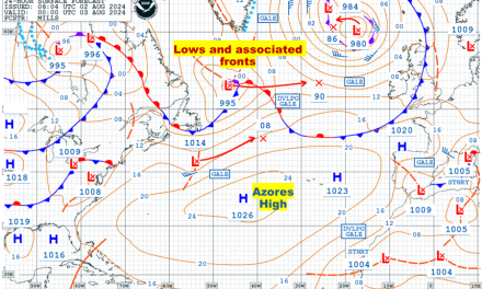
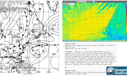
Short-term weather analysis, on the other hand, is based on the analysis of the current situation and the expected weather evolution for the next few days. In this phase, which we could call “tactical”, we will use surface isobar maps and 24h-48h-72h forecasts, etc., GRIB files, web pages such as Passage Weather, weather warnings (GMDSS) and tools (hardware and software) for file downloading, presentation and weather-based routing (Weather Routing).
This short-term weather analysis will help us to make decisions on a daily basis, to look for alternatives in case of bad weather or unfavorable conditions; for example, it may be convenient to delay a departure, change anchorage, change the route to avoid a squall, etc.
In the short term planning, before going to sea we will have unlimited internet and a large number of specialized weather web pages to consult; while once we are at sea, to obtain updated information we will be limited by the bandwidth of our satellite or long range HF/MF (SSB) radio communications.
In this new chapter of the online book “Meteorology and Oceanography for Ocean Navigators” we will see these two phases and we will deal in a general way, as an introduction, with the following aspects:
1. Analysis of long-term meteorology:
a) Pilot Charts.
b) Nautical publications.
c) Climatology tools (software).
d) To investigate and know the sources.
2. Short-term weather analysis:
a) Maps of surface isobars and 24, 48 and 72-hour forecasts.
b) GRIB files.
c) Passage Weather (and other websites).
d) Weather forecasts (GMDSS Forecasts).
e) Weather Routing. Efecúe Log In para desbloquear.Este contenido solo está disponible para subscriptores de navegantesoceanicos.com